

This year, our mother/daughter kayak adventure took Clare and I to Ontario’s north channel. The channel extends 160 nautical miles from Georgian Bay to the St. Mary’s River and runs between the north shore of Lake Huron and Manitoulin Island. Its remoteness, clear water and hundreds of islands (most of which are Crown land) make it an attractive place to paddle and camp, and we hoped to visit three of those islands. As it turned out, we were three days in before it was clear to Clare (and me) that she was travelling with a loser.

With few roads along the north shore, we had only a few options to put-in near the area we wanted to paddle. I stumbled onto a 2010 thread online by some paddlers discussing McBean Harbour in the Sagamok-Anishnawbek First Nation reserve, south of Massey, Ontario. They described it simply as a bay and spoke of two elderly Ojibway brothers living next to the bay that would keep an eye on your car for $3.00/day. Generally, my adventures are carefully planned but instead I just hoped that, 9 years later, they were still there.
Driving from southern Ontario around Georgian Bay takes 5 to 6 hours but we chose a slower route, although shorter in distance. We drove up the Bruce Peninsula, crossed to Manitoulin Island on the ferry from Tobermory and then drove over the swing bridge at the north end of the island to Ontario’s north shore.

At 4 pm we arrived at the Mohawk motel in Massey. It was one of two places to stay and I picked it based on its glowing online reviews: the bathrooms have been updated and the rooms don’t smell like stale smoke. Anybody who has stayed in old, rural motels in North America, knows that those remarks constitute endorsement.
Other than Chutes Provincial Park, there is really nothing of note in the tiny town of Massey. Well, nothing except the Back Home Bistro, which was truly an unexpected find the next morning. Beautifully presented breakfasts, from a hearty bacon/sausage/ham, eggs and toast to eclectic summer offerings of smoked salmon salad, and amaretto-peach preserve French toast, as well as an extensive lunch and dinner menu, make Massey a worthwhile stop on the TransCanada highway.


Driving 25 minutes through the Sagamok-Anishnawbek First Nation reserve brought us to McBean Harbour with its dock and three houses. The four parked cars were encouraging but we couldn’t find a soul and the house next to the dock was derelict. Nobody answered the door at the empty-looking house across the road, and although there was a car, a pickup truck and children’s toys outside the third house, nobody answered our knock at that door either.

We decided to leave a note on the car and were packing our kayaks when two men docked their boat. We learned that the car-minders had passed away years ago but a daughter in the empty-looking house would let us park for $5.00/day. We were still writing our note when she suddenly appeared from nowhere to collect our $25. Happy that the online thread had panned out, off we paddled to Fox Island.


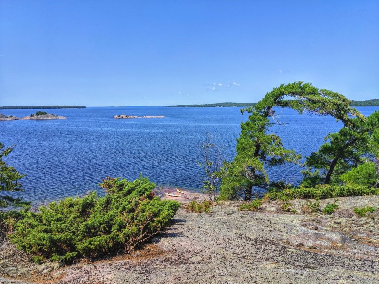
As the afternoon wind picked up, a sheltered cove on the south side seemed the best place to spend the night. Rain and lightning the next day prevented us from going to Croker Island so we set up a tarp, hiked in the rain and explored our surroundings, which were as pretty under the clouds as in the sunshine.
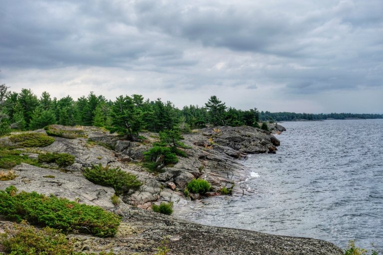


As we crossed to the Benjamin Islands on day three, the loser emerged. I moaned to Clare that I’d lost my phone and that after we picked a campsite, I’d better return to Fox Island to look for it. Two hours later we were on the exposed west side at the southern end of North Benjamin Island and we surfed on the white caps into a slightly sheltered bay.
We landed on a narrow isthmus and 10 steps away, mirroring the exposed west bay, was a protected bay on the east side of the island.
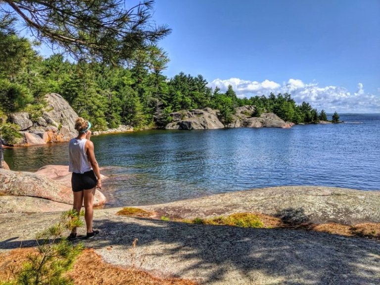
We loved this spot, so stayed for two days. Luckily, the 50 km/hr wind stopped me from paddling back to look for my phone because as I emptied my kayak, there it was on the seat. I’d been sitting on it for the entire day. Eyes rolled beside me.
I celebrated with a drink and life was good until the end of the day when I went out to move the kayaks from their windy spot and lost my new hat. We’d bought hats in Tobermory before the ferry ride. “Where could it be” I kept whining as I searched the kayaks and the campsite. You see, I love hats almost as much as I love sunglasses, neither of which I seem able to hang on to.
The next day, was calm so we paddled around South Benjamin Island. I wore my old hat.

Later that afternoon, I continued my search. “It must have been swept into the lake yesterday by the strong wind while I was moving the kayaks” I told Clare. She looked up from her book. “I can’t see it out there” she replied, scanning the horizon and feigning mild interest.
I temporarily forgot about the hat when a rogue wave washed my swimming suit off the rocks. Another took the biodegradable soap, and one more took the dish. “Clare” I called. “What now?” she replied without looking up. “I’ve lost everything”. No answer. I sprung into action. I’d just put on clean, dry clothes for the evening so I started to strip. As I pulled off all of my clothes and leapt into the water, Clare, overcome with laughter, got up and managed to fish out my bathing suit. Out I swam, fussing about the soap. The laughing got louder. Meanwhile, the soap dish was floating, unabated, out of the bay. Determined not lose anything else, I swam after it, hoping that none of the many boats in the area passed by.
That night, she laughed again while recounting the day. “I couldn’t believe it. One minute you were on shore, the next you were buck naked swimming away. I guess it’s comforting to know you reacted so quickly to a soap dish, should I ever be swept out to sea”.

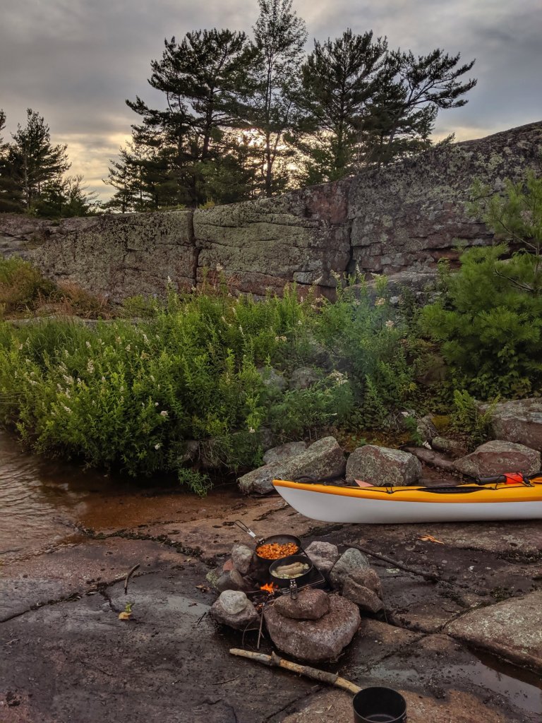
Our wee wilderness home
The next morning, as I flipped over my kayak to pack it, out tumbled my hat. “It was underneath my seat!” I exclaimed. “You said you thoroughly searched your kayak” she replied. I had. Really. The boats were ready to go when I blurted out “I don’t have my raincoat, it’s in a small pouch”. I immediately regretted my words. “No worries, it must be packed” I quickly added unconvincingly. She just smiled.
The early morning sun sparkled on the water and we chatted as she followed closely behind. Then…silence. I turned around and she was gone. I looked all around and called her name three times. I was about to go back when she eventually replied. I squinted into the sun but couldn’t see her at first, Then there she was, a tiny silhouette on the horizon.

“I thought I lost you” I admitted as I paddled over. “Oh my God, I don’t believe it” she laughed. Had loser-paranoia OCD overtaken me, I wondered. As we passed Fox Island, she kindly suggested we stop and look for my raincoat. I protested, rather insincerely I suspect, so we stopped. It wasn’t there. Once back at McBean Harbour, I found it (of course) jammed up in the point of my kayak where it had been for the past three days. (In my defence, I had to hang my head inside the hatch to actually see it).
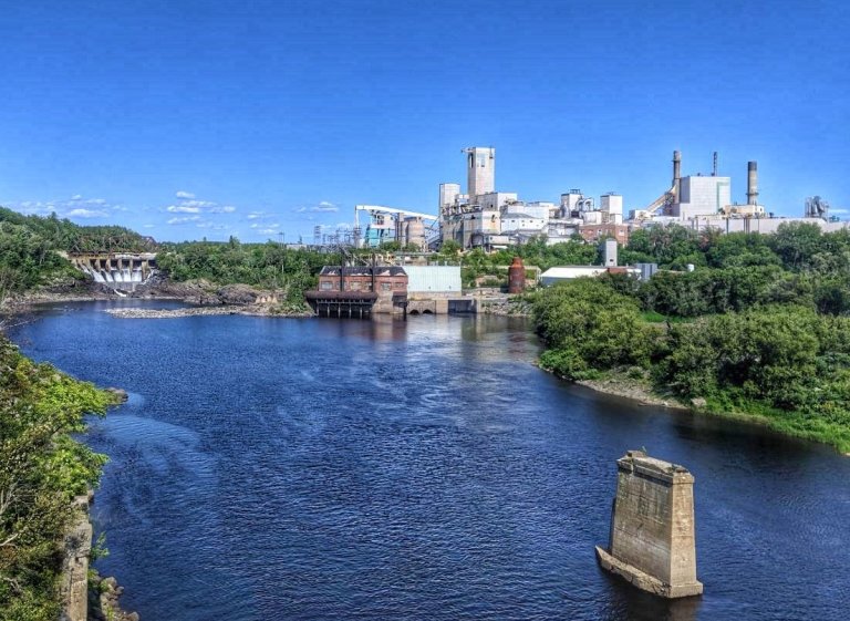
We spent that night in Espanola, not to be confused with Spanish which is 50 km down the highway. How these towns got their names is a mystery. Legend has it that a Spanish woman was brought back by, and married into, the Ojibway after their raid on the Spanish area of the central United States. In the mid-1700s, either the voyageurs or a Jesuit priest (depending on the account) heard Spanish words spoken by the natives in this part of New France and so named the area Espanole.
In 1899, the Spanish River Pulp and Paper company obtained logging rights for the area and built the town and a mill. The mill, which has changed hands many times, has been the mainstay of Espanola’s economy for most of its existence, with a hiatus during World War II when it was used as a German prisoner of war camp. The town was recently the setting for the CBC production Adventures in Rainbow Country.
On our last evening I again lost my hat, this time in The Trading Post where we stopped to shop. I checked all the aisles, twice. It turned up the next morning having found its way into a secret pocket of my handbag. On our drive home the following day, I consciously left everything in the car during our many stops – I’d had enough.
Surprisingly, my daughter is still keen to travel with this loser, and on the ferry back we talked of next year’s adventure. Maybe that’s because we both spent most of our time laughing at the absurdity of my lost and found situations. At home I unpacked and found I wasn’t missing a thing. 🙂 I love the North Channel and you really must go….just keep an eye on your stuff.

I had no idea you were a serial misplacer of items…
LikeLiked by 1 person
Neither did I. This was exceptionally bad!
LikeLike
I totally loved this story. For those of us who are continually guilty of the same affliction we totally understand. Thank you for sharing the info on your fun trip.
LikeLiked by 1 person
Thanks so much. Very comforting to know I’m not alone. 😁
LikeLike